Showing posts with label Woodgrange Estate. Show all posts

The former BBs - 53 Hampton Road

Wednesday, 1 April 2026

Regular contributor, Peter Williams, examines the story of the former BBs, 53 Hampton Road, as part of his irregular series of articles on unusual houses in Forest Gate, and wonders why the once-famous venue can't have its signature BB name etched on the white plaque as it had traditionally been, between the first and ground floors (see below).

The former BBs today - a mixture of 2,3 and 4 bed flats

The property has recently undergone a substantial refurbishment and now comprises very up-market, self-contained flats, with asking rents in the region of £3k per month.

Like 23 Hampton, Peter's previous article in this series (see below), 53 Hampton stands out for its non-residential past within the very residential Woodgrange estate. The original developers of the estate - the Corbetts - insisted on very high standards of maintenance when they began construction 150 years ago, and placed many restrictive covenants on the purposes for which the accommodation could be used - effectively to bar commercial and industrial use of the properties.

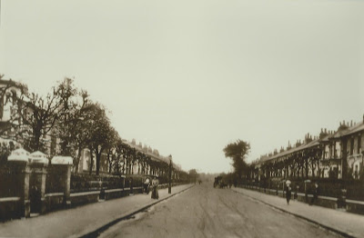
An early 1900s photo of the very orderly Hampton Road. Far right, the estate office, ensuring high standards of residential accommodation were maintained

The estate was granted Conservation Area status by Newham Council fifty years ago, which has also severely restricted conversions of the houses for non-residential purposes since. The non-residential use of 53 Hampton occurred after the Corbetts ceased monitoring changes to the estate and before the Council focused on it as a Conservation Area.

The Moar family was probably the first occupants of the house. They were there at each census from 1881 until 1911. The head of the household was William, an Orkney-born shipping clerk. He and his wife, Hannah, along with their children and domestic servants, made up the list of residents for over 30 years.

There were no registered residents at the property in the 1921 census, which coincides with changes in the property's use, as indicated by its extended layout on the map below.

1930s OS map showing considerable garden extension to no 53 - two properties from the roundabout on the right of Hampton

The National Register of 1939 provides a clue as to what happened after World War 1. There were only two occupants of the house: William King, a retired shipping clerk and Mary Ann Smith, single, 67 years old and described as "caretaker to a dancing school".

Eastern Counties Times article of 18 October 1929 referencing the Elyssa School of Dancing at 53 Hampton

A 1932 book: Who's Who in Dancing stated that:

The Elyssa school of 53 Hampton Road opened in 1910 (ed: the date seems questionable). It had branches in Upminster, Ilford, Upton Park, Bow and Hanover St W1. ... Students are trained for the profession and for stage, with special attention to children's work.

The school was soon having an impact within the West Ham community, as indicated by this press report:

1 May 1937

It advertised its classes regularly in the local press:

West Ham and South Essex Mail - 3 May 1940
 
The school ran until the late 1960s, after which a number of attempts were made over the next two decades to get a change of usage for the property from Newham Council, for flats, to turn it into a place of worship, etc. 

The final attempt was to change the use to "a cultural community and education centre for the Irish community" in 1986. Like all the previous applications, this, too, was rejected. 

A company called Testnow was run from there in  the early 1990s and was wound up under insolvency laws in 1995 - we have no further details of it:

London Gazette 1 September 1995

Soon afterwards the premises became the home of Belford Butler, a former chef at Montego Bay airport who later worked in the kitchens of Forest Gate Community School.

Belford Butler, at the bar

He rebranded the place as BBs, turning it into a music venue for the Afro-Caribbean community, where reggae, dominoes, and Caribbean food featured prominently.

The sign between upstairs and downstairs window, showing the premises to be BBs

He later extended its range to include jazz and offered the venue as a launchpad for local bands. The venue had a small bar and lively audiences. Regular attendees spoke highly of the mix of good music and excellent Afro-Caribbean food that Butler had prepared. They said it was like a house party, but with smoking strictly forbidden.

Flyer for a gig at BBs
Butler was declared bankrupt in 2004 and died four years later:


The building was subsequently leased by a church and then became semi-dormant for much of the time until two years ago when it was taken over by developers and turned into a number of 2,3 and 4 bedroom flats.

Footnote:
We are grateful to a project called Sound Waves: Music in Newham (see here) for some of the material on BBs. There is a QR code on a notice strung to a lamp post opposite 53, which, downloaded, will provide an interesting 4-minute video about the house's period as BBs.

This excellent project has identified a large number of music-related venues in Newham and provides details of them, some via interviews with people associated with, or who have recollections of them, which can be accessed via their website. For details, see here. It is anxious to record more recollections of the locations featured and would be delighted to hear from you if you would like to contribute.

It has also published a short book outlining and summarising its project, with in-depth looks at four venues, including Forest Gate's Lotus Club (see here for our take on the club) and the nearby, now-closed Ruskin Arms. The book can be bought either directly from the project or from our friends at the Newham Bookshop.


23 Hampton Road – one-time host to a factory and a synagogue

Wednesday, 25 February 2026

Regular contributor, Peter Williams, examines some of the fascinating history of 23 Hampton Road, on the Woodgrange estate, as part of his irregular series examining the backgrounds of some of Forest Gate’s more unusual houses.

23 Hampton Road, today
Architects working on the house prior to its sale in 2018, described it thus: “The unusually large rear wings were originally used as a surgical belt factory and later also used as a garment factory”. (here).

As we have previously reported, construction of the Woodgrange estate began in the 1870s. 23 Hampton Road is an odd shape compared with the rest of the street, as the old map below shows, indicating where the factory would have been located. 

23 Hampton - fifth house from the left 
Modern Ordnance Survey mapping shows the strange shape more clearly still:

23 Hampton - fifth house from left
Estate agent’s photographs accompanying the 2018 sale of the property show the scale of the extended wings.

Zoopla

The Woodgrange estate was tightly managed through leases by the original developers, the Corbett family, so it is surprising that this property looks so different.

The very orderly residential Hampton Road in the early 1900s. On the far right of the photos is the estate office, from which the Corbett family kept a close eye to ensure that high residential standards were maintained, which makes it strange that an industrial premises was permitted at number 23.

The first purchaser of the house, according to its lease was George Wheeler, "an anatomical belt maker". The 1881 census showed him to be the 49-year old head of household, employing “6 girls and one boy”, probably in the enlarged wings of the house.

A clue as to why the house had extended wings is to be found in the original 1880 lease for the property. Wheeler's address, as purchaser of number 23, was given as 18 Hampton Road, suggesting that as 23 was being constructed, he commissioned a bespoke design of the house, to accommodate his factory, from his then residence, almost opposite.

A decade later, Wheeler was still the head of household and now described as a widower. The only other occupants of the house were two domestic servants. Wheeler’s occupation was now described as a “Surgical instrument maker,” consistent with the description provided by the architects in 2018.

Evidence of the property accommodating the small factory can be found in a 1894 Kelly's Directory (below), describing it as "Leopold House":

Kelly's Directory 1894

"Leopold House", Hampton Road,  was the address given in an advert seeking  sewing machinists for the factory there:

London Daily Chronicle 20 Dec 1883
By the time of the 1901 census, the Dawes family were living in the property: Elijah Seale Dawes, his wife, Emily, two daughters, and a domestic servant. Elijah was born in Stoke Newington in 1858 and was an ironmonger. There is no evidence of a factory on the premises at this time. The Dawes family were still there a decade later. By 1921, Elijah was retired and living in Wanstead.

The house was inhabited by Philip Wolfers and his family in 1921. 62-year-old Philip was born in Spitalfields and was described as retired in the census returns. He had been a teacher and a Rabbi in South Wales, later serving the Walthamstow and Leyton Synagogue (see press extract). His 61-year-old wife, Louisa, was born in Amsterdam, and their 29-year-old son, Abraham, a self-employed shopkeeper, born in South Africa. Lionel was the youngest member of the family, having been born in South Wales, presumably when Philip was a Rabbi there, in 1900.

Wathamstow and Leyton Guardian 17 Mar 1915
Although described as retired, Philip appears to have used 23 Hampton as a small synagogue, probably located within the enlarged wings, during his time there, as indicated by an announcement of its closure as a synagogue in 1931.

The London Gazette 22 Sept 1931

Within a year of the house’s closure as a synagogue, it was occupied, at least in part, by wholesale poultry salesmen, who formed part of what was emerging as a House in Multiple Occupation, a familiar fate of many houses on the Woodgrange estate during the inter-war period.

By the time of the 1939 National Register, twelve people lived at number 23: four members of the Toomey family, retired naval pensioner George Raffin and his wife, George Kingsworth, Henry Bone and four members of the afore-mentioned Barnett family.

The head of the Barnett family was Nathan, a 63-year-old Russian Jew who emigrated to England in 1898. He had run-ins with the police and was imprisoned in 1943 for breaking World War 2 food and rationing restrictions. 

Chelmsford Chronicle 29 Jan 1943

Nathan's son, Louis, also had problems with the police. He was part of a conspiracy involving false medical evidence presented during World War 2, to avoid being called up for military service, for which he received a two-year prison sentence.

South Essex Mail 5 July 1940


Woodgrange estate – WW2 bomb damage

Wednesday, 11 February 2026

World War 2 reshaped the Woodgrange estate like no other period in its 150 year history. Records of bomb damage in London indicate that the area was hit on ten separate nights during the Blitz (1940-41) and on three occasions during the V1 and V2 bombing raids in 1944 (Fn 1).

The bombs transformed the estate's appearance, particularly at its western end, as a casual glance today will show.

For all of the bombing raids and the scale of the destruction, surprisingly few civilian deaths were recorded, according to West Ham's WW2 register.

 Bomb damage to Woodgrange estate during the Blitz


1940 
Sept 8 – Hampton; 9 – Osborne; 23 – Hampton; 28– Windsor; 
Oct 4  – Hampton; 
Dec 3 – Claremont
 
1941 
Jan 21 – Osborne; 
Mar 8/9 – 3 x Claremont; 19 – Hampton; 
Apr 17 – Woodgrange Methodist church and Claremont and Osborne.


Woodgrange estate bomb hits during V1 and V2 raids 
1944 

Jan
30 – Claremont; 
Feb 24 – Windsor; 
Jul 5 – Osborne.

Deaths were recorded on only two of the nights of bombing during the Blitz and on none during the V1 and V2 raids towards the end of the war.

The estate’s first civilian war deaths occurred on the night of 4 October 1940, when Hilda Humphries and Joyce Humphreys, both aged 23, were killed at 73 Hampton Road. We know little more about the sisters, as they did not appear to be living at the address on the night of the National Register, recorded just a year earlier in September 1939.

73 Hampton Road today - constructed after 4 October 1940 bomb

The bomb clearly destroyed the building, as the house there today is a replacement and of post-war construction. It stands out in contrast to the area's late Victorian dwellings.

The most devastating night of bombing for the estate was on 17 April the following year, when bombs destroyed the Methodist church on Woodgrange Road and hit the adjacent Claremont and Osborne Roads. A considerable bomb site was created, the uses to which it was put are considered below. It was the last night of the Blitz to hit the estate.

Woodgrange Methodist church after bomb damage of 17 April 1941

Five of the estate’s civilians were killed on the night of 17 April. Other people with home addresses outside of the estate may well have been killed, too.

The Register of Civilian Deaths records that Rosetta and Ruth Cohen of 3 Claremont Road, Lucy and William Bruce, next door at number 5, and Myer Cash, opposite at number 6, were all killed that night.

West Ham's Book of Civilian Dead - courtesy of Newham Archives

The 1939 National Register records that number 3 was occupied by six members of the Cohen family, all in the rag trade. Sisters Rose (aged 33) and Ruth (aged 17) were both single and a hand embroiderer and dress machinist, respectively.

Neither the Bruce family nor Myer Cash were shown to be living at their 1941 address at 5 and 6 Claremont on the night of the Register.

We have no details of which houses were bombed on each street during the bombing raids, but some of the hits were clearly serious, as indicated by some post war infill buildings on both Windsor and Claremont Roads.

Deaths were recorded on only two of the nights of bombing during the Blitz and on none during the V1 and V2 raids towards the end of the war.

A block of post WW2 bomb damage replacement flats on Claremont Road

Temporary Fire station on Claremont Road

Following the bombs of 17 April, a considerable bomb site was created. Originally, a plan was made to replace the damage with allotments, as part of the Dig for Victory campaign. This was later revised, and a temporary fire station was erected in preparation for any future raids on the immediate area (Fn 2). It was constructed between the bombed-out Methodist church and number 23 Claremont, which survives, as the first on Claremont Road.

Diagram showing layout and dimensions of temporary fire station on Claremont Road

The diagram above shows a fire engine room, a dormitory, an office/store, and a watch room, where phone calls about incidents were received and firefighters were ready to respond.

The buildings were temporary and likely constructed of corrugated iron.

Location of temporary fire station today - between the post war flats and 23 Claremont

The devastation created by the bombs at the western end of Claremont, Windsor and Osborne roads remained for almost a decade and a half, as a chilling reminder of the Blitz, as the photographs below, dated March 1955, show. 

The height of the trees that grew after the bombing, as shown in many of the photographs below, indicates just how long the site had lain derelict.

1955 Across Claremont, to Windsor

1955 From opposite 21 Windsor, looking west

1955 Looking across Claremont to Osborne

1955 Looking across Claremont

1955 Looking along Windsor

1955 Looking along Windsor

1955 Looking along Woodgrange, Osborne to the left

1955 Looking from junction of Osborne and Woodgrange


1955 Windsor Road - then bomb damage

The photographs were taken by West Ham’s planners as they prepared for post-war reconstruction of the area. The photographs are in Newham’s archives, for whom we are most grateful for the right to reproduce them.

Meanwhile, West Ham’s architects were working on plans to build on the site. The diagram below is their 1954 redevelopment plan.

West Ham architects' plans for bomb site along Woodgrange Road

Not all buildings are completed. What is now Donald Hunter House (Fn 3), originally Telephone House, was built in 1958.

Donald Hunter House, constructed 1958 on site of bomb damaged Windsor/Woodgrange Roads

The Methodist church was similarly at work to replace its bombed-out premises.

Modern Methodist church on Woodgrange Road, while still functioning


Footnotes

1.    1.  Bomb Census survey 1940-1945 - The National Archives

2.   2. E7 Now & Then: Claremont Road temporary WW2 fire station

3.   3. E7 Now & Then: Woodgrange Road developments

Edwardian postcards of the Woodgrange estate

Saturday, 18 August 2018

The Edwardian era (1901 - 1910) witnessed a boom in the use of picture postcards as 'social media', in the days before the introduction of domestic telephones.

There would have been four or five postal deliveries a day, and people could conduct a correspondence about travel and meeting up arrangements, when visiting each other, for example, with the greatest of ease, over a few hours.

Among the most popular of the postcards were photos of prominent local streets, churches and parks. So, West Ham Park and Wanstead Flats are well represented, as are almost all local churches of the time. There are literally dozens of different surviving views of Woodgrange Road and small numbers of some local streets - usually the more prosperous (Earlham Grove, Capel Road, Chestnut Road being good examples).

People used the postcards, employing the relatively recently developed use of mass reproduced photography, as a combination of a calling card and an illustration of their locality, or residence.

The streets of the Woodgrange estate are all well represented, and this article features a number of the postcards, which collectively inform our understanding of the development of the estate, as well as present a nostalgic glance back to a car-less era of wide, uncluttered roads.

Many of the postcards of the era survive, and there is a busy, and increasingly expensive, market for them on E.Bay. There are at least two local collectors of Forest Gate life, Tony Morrison, a friend of this site, and another equally valued contact, who wishes to remain anonymous.  We are grateful to both for sharing relevant sections of their collection with us, so that we can display them in this article.

One rather splendid set survives of all four of the main roads on the estate. The photos are all hand-tinted and indented on high quality photographic paper/card, to give the appearance of a framed photograph. We reproduce the four- as a set - in minature, including their frames, here. We produce larger versions, without frames, so that the details can be examined more closely, in the separate road sections, below.


Top: Windsor and Osborne, Bottom: Hampton and Claremont

We are covering the main roads on the estate from south to north. In very broad terms, that was sequence of grander to less grand houses in the estate, according to the surviving 1878 sales leaflet for the houses - see below. 

As the leaflet shows, the earliest houses on Windsor had the widest frontages (47 feet) and were most expensive (£590). Then came those on Claremont (44 feet, £530), followed by Osborne and Hampton (both 39 feet and £490).

It is those largest and most expensive houses on Windsor and Claremont that were bombed during WW2 and replaced by the 1950's estate.


Below is a rare postcard of one of the largest of the original houses on the estate. It is of 4 Windsor - with its 47 feet frontage. It is unusual in a number of regards. Firstly, as the sign on the far left indicates, it doubled up as a house and a Music and Dance Academy. Kelly's Directory of 1902 shows that it was occupied by "Madame Marian Finer, Professor of Music" and Thomas Owen Finer.

The 1911 census shows the same couple, with a 25-year old daughter, Edith. It also suggests that Marion married Owen when she was just 16, and he 40, for in 1911 they were 45 and 70 respectively.

The house has a conservatory at the front. We have seen no evidence, photographically, or in writing of any other house on the estate having such a feature.  Many houses on the estate had verandahs - some of which survive - but none other, as far as we are aware, a fully enclosed glass frontage of the kind shown below.

The photo suggests that the house was quadruple fronted, with an arch under the left hand extension leading either to the garden or perhaps to a coach house, at the rear. 

4 Windsor Road, in 1908. 
Destroyed by WW2 bomb.

The sales leaflet, above, mentions the estate office.  The manager was Mr Donald. This was located at 2 Hampton Road, and can be seen protruding from the fabric of the house in the postcard below.

The estate office was important, for many years after the houses on the estate were constructed and sold.  Most were sold on a leasehold basis - for 99 years, in the 1880's. Others, as the leaflet suggests, were rented;. Those sold had a significant ground rent to pay each year. 

Corbett, the estate's developer, was fastidious about maintaining high standards on the Woodgrange estate. The original sales contract for the houses, for example, insisted that the purchaser kept the house in good repair, "and particularly will paint the external wood and ironwork in every Fourth year of the said term and the inside wood and ironwork in every Seventh year of the said term." 

Corbett reserved the right to inspect all houses that he had "sold" twice a year, to ensure that this was adhered to, and required any concerns to be addressed within three months.

Anticipating the Conservation Area requirements, imposed a century after the construction of the estate, the house deeds stated: 
The Lessee ... will not make any alterations in the plan or elevation or in the architectural decorations of the said dwelling-house or any additions thereto or erect of build any new or additional building on any part of the said premises without the previous licensee in writing of the Lessor.
The upshot of the conditions imposed on the initial purchasers of houses on the estate was that conformity of high standards was enforced - through the estate office.  So, in many of the photos below, it will be clearly seen that the trees in gardens were  pollarded and pruned together - to ensure a consistency and uniformity of appearance.

Corbett began to sell the freehold of houses in the estate twenty five years after they were first erected - possibly to finance some of his ambitious housing schemes in south east London (see here, for details). It was only at that point that the owners were able to "individualise" their houses and make significant changes to their interiors, or exteriors.

The postcards reproduced below, therefore, probably display the houses on the estate at their most uniform and mature - reflecting the kind of vision Corbett and his heirs had for the estate - neat, tidy, well-ordered and maintained to a consistently high standard.
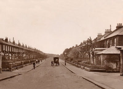
The estate office, protruding from 2 Hampton
 Road, above, in the postcard.
Below, the same building, boarded up, today


Almost all of the postcards reproduced below are of the Edwardian era - as testified by the stamps and frank marks on the correspondence side of the card. Some are later, though difficult to date, if they have not been posted.

It is noticeable that all gardens hosted three or four trees, which were maintained by the freeholder. There were no trees on the pavements at this time - which taken together with the lack of traffic on the raods give the impression of wide, distinctive boulevards.

The approach in this article is to display general views of each street, as chronologically as possible, followed by rather more specific (sometimes single house) postcards.  With these later cards we have, wherever possible, tried to produce a "now" version of the view today. In some cases the destruction of some of the original features of the houses makes for uncomfortable viewing.

Windsor Road

Tinted postcard of Windsor c 1908, from the series, 
mentioned above. Note consistent pollarding 
of the trees, suggesting considerable 
on-going involvement of the leaseholder
 (Corbett) in the appearance of the estate. 


Undated postcard of the entrance to
Windsor Road, from Woodgrange Road


Second house on right hand side is number 4
(see above) - a slight impression of the
conservatory at the front, which does not
seem to be present  on any other house

Above and below: noticeable that one front
wall stands out from all the others in being of 

a paler brick. Given the attention to symetery
 and detail elsewhere in the houses, perhaps this
was the first to exercise the "right to buy" the
freehold, and so express individuality - like 

"right to buy"  council properties in the 1980's?

Above: undated postcard of roundabout on
 Windsor  and Richmond Roads. Below: the 
location today. The railings around the 
roundabout were doubtless taken down 
and used to help the war effort in WW2.


West end of Windsor Road, post WW2 bombing,
 prior to construction of modern estate of flats

Above: unusual postcard of the east end of
Windsor Road, at its junction with
Hampton. Judging by the height of trees, 

likely to be Edwardian.
Below: the view, today.


Above: Edwardian postcard of 54 Windsor Road.
Below: a treeless and hedgeless 54 Windsor Road,

 today, complete with a first floor extension to the annexe


Claremont Road
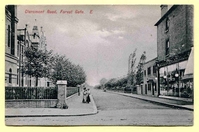
The Claremont card from the 1908 had-tinted set.
 To the left is the Woodgrange Methodist church,
 bombed during WW2. The white stone capped
 pillars on the right were an entrance to the church.
 The buildings on the far right were the side and
 back of Woodgrange Road shops, also bombed
 during WW2, and replaced by the surviving
 1950's estate.

On the corner of Woodgrange, with the 
pre-bombed  Methodist church on the left.
 The composition  is very similar to the second
 postcard of Windsor Road, above -
-suggesting they were possibly part of a set

Above, uniformly post pollarded trees, in the
 winter. Below trees in full leaf, in the summer.
As with all these postcards it is noticeable
not at just how little traffic there is on the road,
but how few pedestrians there are, too.
Almost all of them seem to be children
 or young people.
 

Judging by the maturity of the trees, a slightly
later postcard.  The white capped posts on
the bottom left mark the entrance to the Methodist
church - see above, for further evidence.

Above: Edwardian 30 Claremont Road. Below:
 the house today. "Modernised" before the estate 
became a Conservation Area. The trees and 
hedges have gone. "Modernisation" has resulted 
in newer, out of character, windows, a porch 
and pebbledashing.
 

Osborne Road

Fewer postcards seem to have survived of Osborne Road. The first two, below, have been taken from very similar positions. The red-tinted building on the far left is the side of what is now the Woodgrange Medical Practice, on Woodgrange Road. Immediately behind it is the end of a row of what were coach houses, or mews and are now an unsightly alley of garages.

The white-capped pillars and taller iron fences on the left hand side are where Kay Rowe Nursery is today, and mirror those of the Methodist church entrance in Claremont Road, above. 
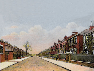
One more in the 1908 hand-tinted series of
local postcards - see Windsor and Claremont,
above, for others in the set.
Slightly later postcard,
shot from a similar location

An even later postcard, with taller,
but still uniformly well-pollarded trees
 Hampton Road
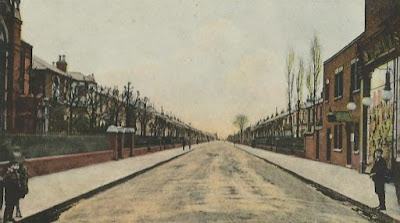
The Hampton postcard from the 1908 hand-tinted
 set. Lower roofed buildings on near left and
right would have been coach houses. First house
on right was the estate office - see text above.
A later shot, from a similar angle, but this
time with more mature trees and - for the
first time, telegraph poles.
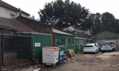


The mews, coach houses, at the side
of number 2, today, in a run down state
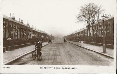
A later shot, with more mature trees,
and the suggestion of a verandah on the
first house on the left.
 
A more unusual shot - looking west, towards
 Woodgrange Road. The shop at the far end is
 the studio of William E Wright, the photographer
 featured on this website.

Above: 85 Hampton - then, and below, now.
  The house is today obscured by over-grown trees
 - hence the partial view.

Above - 88 Hampton, then. Below - now: garden
 fence, trees and hedge removed, with a first
floor annexe built and part of garden turned into
hard standing for a car. In a sign of changing
times, chimney stacks replaced by satellite dish.